The Village 1500 to 1800 AD
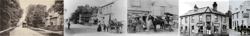
During the 16th and 17th centuries the village grew little in actual size as the population statistics show but there were noticeable changes in its appearance. This is true not only in Shelford but over most of this country, for during these years economic and social changes produced what has been termed "The Great Rebuilding". In all classes of society, except perhaps the lowest, new ideas and standards of living arrived and the result was a host of new and improved houses many of which are still there today. In Shelford a large number of late 16th century and 17th century houses remain to show us that a new class of prosperous farmers was emerging .who wanted a higher standard of living. The majority of the new houses built by these people conform to a standard plan of three adjacent rooms with a single centrally placed chimney stack which provided the heating for the central living room and sometimes for one of the end rooms which was the parlour. This development of a separate sitting room in small houses is important for it marked the development of the idea of privacy in houses of this type. Privacy had been non- existent in the average small medieval house where normally everyone lived in one room. Similarly the division of the upstairs into bedrooms also meant a new standard of privacy which had been unknown before.
Of the 16th and 17th century houses in Shelford the best include the cottages opposite the church, 15-19 Church Street, now three dwellings, but originally built as a single substantial farmhouse around 1600; Oak Cottage, High Street, another farmhouse dating from around 1550 and Spanyards at High Green which was also a three roomed farmhouse when it was built in the 17th century although it has been altered and extended at a later date. All these are visually attractive houses, and clearly of some antiquity, but other houses in the village not so obviously old are of the same period. Malyon's the butchers is also probably of the 17th century though many additions and alterations have obscured the original form. Bridge House, on the Cambridge side of the railway, is also of 17th century date, though it has been entirely covered in 19th century brick and there is little on the outside to reveal its true date.
Other houses in the village were altered during these years. Of these de Freville Farm is of particular interest. As we noted earlier the south end is of late 15th century date being the crosswing of an open medieval hall. But by the end of the 16th century an open hall was old fashioned and had no privacy for its owners such as was by then desirable. So the whole building, except for the crosswing, was pulled down and a new building erected with a large sitting room and kitchen wing with bedrooms above.
Another house which was rebuilt at this time was The Grange. Here we do know something of its history. In the late 16th century both the Manor House and its land were sold for the first time. Most of the land was later sold again in 1614 to Caius College Cambridge, but the house passed into private ownership. As a result it was then entirely rebuilt early in the 17th century. Of this rebuilding little remains after a massive reconstruction in the late 19th century, but the eastern crosswing is still largely of early 17th century date, while the present plan of the rest of the house probably preserves something of the original layout.
All these new houses were built of wood, with a basic timber frame infilled with lath and plaster, and then plastered over to hide all or most of the timber structure. The modern fashion for stripping off this plaster and exposing the original timber framing has no historical basis. The poor quality of the timber work thus exposed is ample evidence that it was never meant to see the light of day. Any self- respecting 17th century farmer took great care to cover up the rough timber framing when building his house. Nevertheless, occasionally something interesting can be seen when the timber framing is exposed today. The house, now two, at the west end of Church Street, numbers 38 and 40, which was originally a substantial 17th century farmhouse, had its plaster removed some years ago. The result is that the original carpenter's marks for numbering each piece of timber can now been seen. They are small neatly cut: Roman numerals on all the separate pieces of wood, presumably done to help the builders erect the basic frame of the house when it arrived in pieces on the site.
A minor work of the early 17th century of little importance to the people of Great Shelford was the construction in 1610 of the "New River" or Hobson's Brook from Nine Wells in the north of the parish into Cambridge. The scheme was intended to supply water for drinking, street cleansing and scouring drains for Cambridge by carrying water from Nine Wells along a new water course through Trumpington to Lensfield Road in Cambridge. From there it passed into culverts and drains for distribution round the town. This water course was described as "newly and lately made " in 1610 as it passed through the fields of Trumpington and the present water channel from Nine Wells to the Trumpington parish boundary, which is made up of three exactly straight cuts, is probably of the same date. The cost of the scheme was borne jointly by the town and the university. The carrier Thomas Hobson who later gave his name to the system and one Samuel Potto both left properties as endowments for the upkeep of the waterworks.
The 18th century history of the village was dominated by a steady increase in population. From 1700 when there were some 300 people living there, the population rose to 570 in 1801. All these people had to be housed and as a result two important changes took place, both of which can be seen today. First and most obviously new houses were built. Some were squeezed in between existing houses, while others were erected on the outskirts, continuing the process of building along the edges of High Green. In addition some new houses were erected on the green along the east side of High Street. All were still in the 17th century tradition being basically of three rooms and completely constructed of timber. Many of these houses, probably of poor quality, have now gone. Among others which still exist are White Cottage in High Street, also early 18th century in date, and number 68 High Street which was built around 1750. Of the new houses along the edge of High Green, Four Mile House is a good example. It too is early 18th century, timber framed and plastered, though in this case fake timber framing has been painted on the plaster.
New houses alone however could not cope with the demand for homes by the end of the 18th century and as a result many of the existing houses in the village were divided up into tenements. This is a process which became even more important in the 19th century with the continuing rise in the population but it had certainly started by the late 18th century. We shall deal with this in more detail later.
Naturally the upper classes of village society kept abreast with fashion in the 18th century, and one of the most interesting houses which show this is The Red House in Church Street, opposite The Grange. It was originally built sometime between 1700 and 1720, though only to half its present size. The rear part was added in the 19th century. With its large windows and symmetrical front elevation it epitomises gracious 18th century living.
One event of the 18th century in the village was the collapse of the church tower in 1798. The fall resulted in the almost complete destruction of the westernmost bay of the nave and aisles. Therefore when rebuilding started, the new tower was erected a little to the east of the old one on the site of the west end of the nave. This was undoubtedly to save money.
The last major change in the village in the 18th century was a great improvement in the road system. In the Saxon period the major through roads were the present Cambridge, Granham's and London roads and Hinton Way, all of which joined to become the present High Street and Woollards Lane which in turn joined to pass through the original Shelford village and across the river. The continuation of Woollards Lane along the river edge to Hauxton Mill was also probably important. The growth of medieval Cambridge and the increase in north to south traffic between London and Cambridge probably led to the development of Tunwell's Lane as a through road which in effect by-passed the original village. Thus the basic road system of the village was established. Throughout the whole of the medieval period and indeed up until the early 18th century these roads remained rough tracks, dusty in dry weather and no doubt almost impassable in wet. The 18th century however saw a countrywide improvement in roads as a result of the establishment of Turnpike Trusts, who took over responsibility for many major roads in return for tolls collected from travellers. Great Shelford was an early beneficiary from this system. In 1724 the Cambridge-Chesterford Turnpike Trust was set up by Act of Parliament with powers to improve the road and collect tolls between Cambridge and Stump Cross near Great Chesterford. This road passed directly through Great Shelford via the Cambridge Road, Tunwell's Lane and London Road. In 1729 another Act of Parliament was passed which allowed the same Turnpike Trust to take over the old road from High Green through the village to Little Shelford and on to Whittlesford. As a result two of the major roads through the village were radically improved. As well as improving roads themselves the Turnpike Trust also carried out other works. Amongst these was probably the rebuilding of the two bridges across the River Cam between Great and Little Shelford which date from the late 18th or early 19th centuries. The positions of the toll houses and their gates where the tolls were collected are not known with certainty. One stood where the present Plough Inn is on High Green and presumably at this point tolls were collected from people passing through the village to Whittlesford and beyond.
One other minor 18th century road improvement which hardly affected the people of Great Shelford was the rebuilding of Wort's Causeway, the road along the N.E. edge of the parish from Red Cross towards Fulbourn. This road is actually the Roman road from Colchester to Cambridge and was later a trackway leading towards the Gog Magog Hills. In 1709 Wiliiam Wort left ?1, 500. for building a causeway to the Gogs and an annual sum of money for its upkeep. The present road is on this causeway which remains as a large embankment 17 feet wide and 3 feet high; It was much used in the 18th and 19th centuries as a fashionable way to the Gogs for Cambridge people. In 1763 it was said that "gentlemen ride out clean in the depths of winter"
Page last updated October 29th 2009